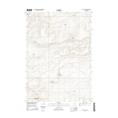
2015 Map of Potato Butte
USGS Topo · Published 2015About this map
The high-desert terrain of Fremont County and Hot Springs County is defined by isolated mesas and the vital water sources that sustained early activity in this arid region. The namesake Potato Butte and the broad plateau of Big Table Mtn anchor the landscape, while the presence of Miners Gulch suggests a history of prospectors seeking resources in the draws and canyons. Drainage systems like Dry Cottonwood Cr and Willow Cr cut through the high ground, fed by numerous named seeps such as Sweetwater Spring, Merrill Spring, and Rainwater Spring. This reliance on specific water points indicates a pattern of land use focused on livestock and seasonal grazing. The boundary between the two counties passes through this high-elevation territory, where the only significant road access is recorded via Canyon Rd in the southeastern portion of the quadrangle.
Find a feature on this map
31 named features on this map. Tap any name to fly to it.
Don’t see what you’re looking for? This feature index may not catch every label — zoom into the map to look around manually.
Map Details
Editions of this 2015 Potato Butte Map
This is the sole edition of this map. No revisions or reprints were ever made.
Other maps of this area

1951 · Mexican Pass
USGS Topo · 1:24,000

1951 · Morrison Canyon
USGS Topo · 1:24,000

1951 · Jenkins Mountain
USGS Topo · 1:24,000

1952 · Kates Basin
USGS Topo · 1:24,000

1955 · Thermopolis
USGS Topo · 1:250,000
1957 · Jenkins Mountain
USGS Topo · 1:24,000

1958 · Thermopolis
USGS Topo · 1:250,000

1962 · Thermopolis
USGS Topo · 1:250,000

1965 · Arapahoe Ranch
USGS Topo · 1:24,000
1965 · Potato Butte
USGS Topo · 1:24,000