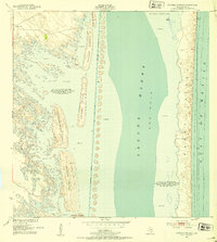
1952 Map of Potrero Cortado
USGS Topo · Published 1953About this map
Padre Island and the shallow coastal waters of Kenedy County dominate this 1952 topographic study, revealing the complex barrier system of the Texas coast. The landscape is defined by the Intracoastal Waterway, which cuts a straight path through the Laguna Madre, flanked by a long chain of Spoil Banks. To the west, the mainland edge is characterized by several distinct potreros, or elevated pasture lands, including Potrero Cortado and Potrero Farias. These areas rise above the surrounding Sand and Mud flats, which are subject to occasional inundation based on meteorological conditions. Local water sources are marked by isolated features like the Medanito Well and Lopeno Artesian Well, essential infrastructure in this arid coastal environment. The boundary between the sheltered lagoon and the open Gulf of Mexico is maintained by the shifting dunes and terrain of the barrier island, where features like Cuba Island and The Hole indicate the variable depths of the Laguna.
Find a feature on this map
18 named features on this map. Tap any name to fly to it.
Don’t see what you’re looking for? This feature index may not catch every label — zoom into the map to look around manually.
Map Details
Editions of this 1952 Potrero Cortado Map
3 editions found
Other maps of this area

1923 · Lopena Island
USGS Topo · 1:62,500

1923 · Saltillo Ranch
USGS Topo · 1:62,500

1928 · Sarita
USGS Topo · 1:125,000

1950 · Corpus Christi
USGS Topo · 1:250,000

1951 · Potrero Lopeno NW
USGS Topo · 1:24,000

1951 · Sarita 4 NE
USGS Topo · 1:24,000

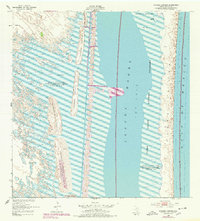
1952 · Potrero Cortado
USGS Topo · 1:24,000

1952 · Yarborough Pass
USGS Topo · 1:24,000

1952 · Sarita 4 SE
USGS Topo · 1:24,000

1952 · Potrero Lopeno
USGS Topo · 1:62,500