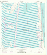
1951 Map of Potrero Lopeno NW
USGS Topo · Published 1978About this map
Potrero Lopeno and the barrier islands of the Texas coastline define this mid-century maritime landscape. This survey captures the transition of the region as the Padre Island National Seashore was established, documenting the complex system of shifting sand dunes and expansive deposits of sand and mud that characterize the barrier environment. The Intracoastal Waterway cuts a distinct path through the Laguna Madre, flanked by a series of spoil banks that mark the human engineering required to maintain this vital shipping route.
Find a feature on this map
13 named features on this map. Tap any name to fly to it.
Don’t see what you’re looking for? This feature index may not catch every label — zoom into the map to look around manually.
Map Details
Editions of this 1951 Potrero Lopeno NW Map
3 editions found
Other maps of this area

1923 · Lopena Island
USGS Topo · 1:62,500

1923 · Saltillo Ranch
USGS Topo · 1:62,500

1928 · Sarita
USGS Topo · 1:125,000

1950 · Corpus Christi
USGS Topo · 1:250,000

1951 · Potrero Lopeno NW
USGS Topo · 1:24,000

1952 · Potrero Lopeno SE
USGS Topo · 1:24,000

1952 · Potrero Cortado
USGS Topo · 1:24,000

1952 · Sarita 4 SE
USGS Topo · 1:24,000

1952 · Potrero Lopeno SW
USGS Topo · 1:24,000

1952 · Potrero Lopeno
USGS Topo · 1:62,500