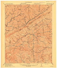
1914 Map of Pound
USGS Topo · Published 1914About this map
Pine Mountain dominates this 1912 survey, forming a massive natural barrier along the border where Kentucky and Virginia meet. The landscape is defined by a dense network of mountain gaps and hollows, where the early twentieth-century economy was driven by the extraction and transportation of resources. In the north, the burgeoning coal and rail activity is evident around Jenkins and Fleming, while the surrounding slopes are dotted with localized community centers. Educational infrastructure is remarkably visible through numerous rural schools, including the Gilley School, Yonts Fork School, and Meade School, reflecting the scattered settlement patterns of the era. Waterways like Elkhorn Creek and Wright Fork cut through the steep topography, providing the narrow corridors used for early roads and rail lines. The map captures the region at a transitional moment as large-scale industrial operations began to reshape the Central Appalachian coalfields.
Find a feature on this map
144 named features on this map. Tap any name to fly to it.
Don’t see what you’re looking for? This feature index may not catch every label — zoom into the map to look around manually.
Map Details
Editions of this 1914 Pound Map
4 editions found

Other maps of this area

1886 · Grundy
USGS Topo · 1:125,000

1890 · Whitesburg
USGS Topo · 1:125,000

1890 · Grundy
USGS Topo · 1:125,000

1892 · Grundy
USGS Topo · 1:125,000

1892 · Whitesburg
USGS Topo · 1:125,000

1894 · Estillville
USGS Topo · 1:125,000

1897 · Bristol
USGS Topo · 1:125,000

1902 · Bristol
USGS Topo · 1:125,000

1912 · Pound
USGS Topo · 1:48,000

1912 · Hindman
USGS Topo · 1:48,000