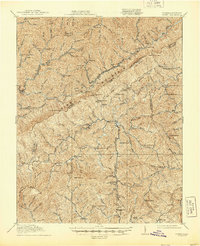
1914 Map of Pound
USGS Topo · Published 1944About this map
Pine Mountain forms the dramatic backbone of this Central Appalachian landscape, marking the rugged boundary where Kentucky and Virginia meet. The area is defined by its strategic mountain passes and the headwaters of major drainage systems, including the Kentucky River and the Pound River. The settlement pattern follows the narrow valleys, with the coal towns of Jenkins and McRoberts appearing as significant industrial hubs served by the L and N RR. These communities, along with Dunham and Burdine, reflect the early 20th-century economic expansion into the Cumberland Plateau.
Find a feature on this map
105 named features on this map. Tap any name to fly to it.
Don’t see what you’re looking for? This feature index may not catch every label — zoom into the map to look around manually.
Map Details
Editions of this 1914 Pound Map
4 editions found

Other maps of this area

1886 · Grundy
USGS Topo · 1:125,000

1890 · Whitesburg
USGS Topo · 1:125,000

1890 · Grundy
USGS Topo · 1:125,000

1892 · Grundy
USGS Topo · 1:125,000

1892 · Whitesburg
USGS Topo · 1:125,000

1894 · Estillville
USGS Topo · 1:125,000

1897 · Bristol
USGS Topo · 1:125,000

1902 · Bristol
USGS Topo · 1:125,000

1912 · Pound
USGS Topo · 1:48,000

1912 · Hindman
USGS Topo · 1:48,000