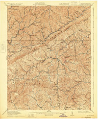
1914 Map of Pound
USGS Topo · Published 1925About this map
Pine Mountain anchors this 1914 survey, serving as the high natural boundary line between Kentucky and Virginia. The region is defined by a dense network of mountain gaps and steep hollows that dictated the early settlement patterns of the Central Appalachian coalfields. Key mining and railroad towns like Jenkins, McRoberts, and Dunham appear during a period of rapid industrial expansion, linked by the Nashville and Chattanooga RR.
Find a feature on this map
91 named features on this map. Tap any name to fly to it.
Don’t see what you’re looking for? This feature index may not catch every label — zoom into the map to look around manually.
Map Details
Editions of this 1914 Pound Map
4 editions found

Other maps of this area

1886 · Grundy
USGS Topo · 1:125,000

1890 · Whitesburg
USGS Topo · 1:125,000

1890 · Grundy
USGS Topo · 1:125,000

1892 · Grundy
USGS Topo · 1:125,000

1892 · Whitesburg
USGS Topo · 1:125,000

1894 · Estillville
USGS Topo · 1:125,000

1897 · Bristol
USGS Topo · 1:125,000

1902 · Bristol
USGS Topo · 1:125,000

1912 · Pound
USGS Topo · 1:48,000

1912 · Hindman
USGS Topo · 1:48,000