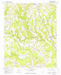
1964 Map of Powhatan
USGS Topo · Published 1976About this map
The community of Powhatan and the rural outskirts of Smithfield define this portion of Johnston County in the mid-1960s. The landscape is deeply etched by watercourses, including Swift Creek, Middle Creek, and Sassaraxa Creek, which are flanked by terrain features like Steep Hill. This region is a collection of several townships including Clayton, Cleveland, and Elevation, characterized by a dense network of country churches that served as the primary social anchors for these farming communities. Notable landmarks include the Short Journey Sch and numerous family-named houses of worship like Averys Grove Ch and Johnston Union Ch. The Southern railroad line cuts through the northeast, facilitating the transport of goods near Wilson Mills while a major Pipeline traverses the center of the sheet, reflecting the integration of modern infrastructure into an otherwise traditional agrarian setting.
Find a feature on this map
44 named features on this map. Tap any name to fly to it.
Don’t see what you’re looking for? This feature index may not catch every label — zoom into the map to look around manually.
Map Details
Editions of this 1964 Powhatan Map
3 editions found

Other maps of this area

1906 · Four Oaks
USGS Topo · 1:48,000

1908 · Four Oaks
USGS Topo · 1:62,500

1953 · Raleigh
USGS Topo · 1:250,000

1954 · Raleigh
USGS Topo · 1:250,000

1964 · Garner
USGS Topo · 1:24,000

1964 · Flowers
USGS Topo · 1:24,000

1964 · Selma
USGS Topo · 1:62,500

1964 · Clayton
USGS Topo · 1:24,000

1964 · Edmondson
USGS Topo · 1:24,000

1964 · Garner
USGS Topo · 1:62,500