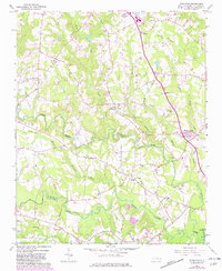
1964 Map of Powhatan
USGS Topo · Published 1982About this map
The confluence of Swift Creek and Middle Creek defines the hydrology of this North Carolina landscape, where small rural communities and family-named landmarks are connected by the Southern railway. The settlement of Powhatan sits in the north, anchored by Powhatan Ch near the junction of winding country roads. This area reflects a mid-20th-century transition, where traditional tobacco-belt agriculture began to share the map with modern infrastructure like the County Airport and a regional Pipeline. Genealogists will find significant value in the distribution of small churches and cemeteries, such as Wesleys Chapel and Oakey Grove Cem, which served as the social centers for the surrounding farmsteads. The presence of the Short Journey Sch points to the localized education system that once served the dispersed population along Little Creek and Steep Hill Branch.
Find a feature on this map
38 named features on this map. Tap any name to fly to it.
Don’t see what you’re looking for? This feature index may not catch every label — zoom into the map to look around manually.
Map Details
Editions of this 1964 Powhatan Map
3 editions found

Other maps of this area

1906 · Four Oaks
USGS Topo · 1:48,000

1908 · Four Oaks
USGS Topo · 1:62,500

1953 · Raleigh
USGS Topo · 1:250,000

1954 · Raleigh
USGS Topo · 1:250,000

1964 · Garner
USGS Topo · 1:24,000

1964 · Flowers
USGS Topo · 1:24,000

1964 · Selma
USGS Topo · 1:62,500

1964 · Clayton
USGS Topo · 1:24,000

1964 · Edmondson
USGS Topo · 1:24,000

1964 · Garner
USGS Topo · 1:62,500