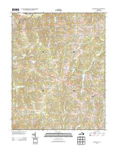
2013 Map of Powhatan
USGS Topo · Published 2013About this map
Powhatan serves as the central hub of this Piedmont landscape, situated just south of the James River as the county entered the second decade of the 21st century. The map illustrates a transitional rural character where traditional settlements like Provost, Jefferson, and Macon are linked by a network of historic corridors such as Cartersville Rd and Old Buckingham Rd. To the northwest, the Powhatan State WMA and Powhatan Lakes define a large protected area for wildlife and recreation. Residential patterns show modern development branching off older routes, with names like Old Plantation Rd and Tilmans Farm Dr hinting at the area's agricultural heritage. Numerous creek systems, including Fighting Cr and Fine Cr, carve through the terrain, while the Plainview Airport near Plain View indicates the modern infrastructure supporting this community west of the state capital.
Find a feature on this map
91 named features on this map. Tap any name to fly to it.
Don’t see what you’re looking for? This feature index may not catch every label — zoom into the map to look around manually.
Map Details
Editions of this 2013 Powhatan Map
This is the sole edition of this map. No revisions or reprints were ever made.
Other maps of this area

1890 · Goochland
USGS Topo · 1:125,000

1891 · Palmyra
USGS Topo · 1:125,000

1891 · Farmville
USGS Topo · 1:125,000

1892 · Goochland
USGS Topo · 1:125,000

1893 · Farmville
USGS Topo · 1:125,000

1895 · Palmyra
USGS Topo · 1:125,000

1897 · Amelia
USGS Topo · 1:125,000

1897 · Palmyra
USGS Topo · 1:125,000

1943 · Goochland
USGS Topo · 1:31,680

1943 · Fine Creek Mills
USGS Topo · 1:31,680