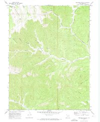
1970 Map of Preacher Canyon
USGS Topo · Published 1973About this map
The Diamond Ridge Gas Field and its associated pipeline infrastructure mark the industrial footprint on this high-desert landscape in northeastern Grand County. At the time of this 1970 field check, the area was defined by its complex drainage network, where the high elevation of Diamond Ridge gives way to deep incisions like Preacher Canyon and Hay Canyon. A series of drill holes and gas wells are scattered across the plateau, reached by a network of jeep trails and a pack trail that emphasize the remoteness of the terrain.
Find a feature on this map
25 named features on this map. Tap any name to fly to it.
Don’t see what you’re looking for? This feature index may not catch every label — zoom into the map to look around manually.
Map Details
Editions of this 1970 Preacher Canyon Map
2 editions found
Other maps of this area

1885 · East Tavaputs
USGS Topo · 1:250,000

1956 · Grand Junction
USGS Topo · 1:250,000

1959 · Grand Junction
USGS Topo · 1:250,000

1960 · Grand Junction
USGS Topo · 1:250,000

1962 · Grand Junction
USGS Topo · 1:250,000

1963 · Tenmile Canyon
USGS Topo · 1:62,500

1963 · Sego Canyon
USGS Topo · 1:62,500

1964 · Grand Junction
USGS Topo · 1:250,000

1965 · Grand Junction
USGS Topo · 1:250,000

1970 · Flume Canyon
USGS Topo · 1:24,000