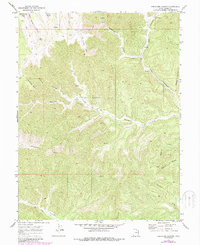
1970 Map of Preacher Canyon
USGS Topo · Published 1987About this map
Diamond Ridge dominates this high-plateau landscape in Grand County, where the topography is defined by deeply incised drainages and the industrial activity of the Gas Field. This 1970 survey, updated in the late 1980s, documents a network of extraction infrastructure including several Gas Wells and numerous Drill Holes scattered across the ridges. Movement through this difficult terrain relies on a sparse system of Jeep Trails and a Pack Trail that follows the contours of Preacher Canyon. Water sources are critical landmarks in this arid environment, with Rock Spring and Red Spring noted alongside Westwater Creek, which carves a major path through the center of the sheet. The map also identifies specific geographic markers such as Jumping Off Point and Survey Point, alongside cattle-handling features like a Corral, reflecting the region's intersection of ranching and energy exploration.
Find a feature on this map
29 named features on this map. Tap any name to fly to it.
Don’t see what you’re looking for? This feature index may not catch every label — zoom into the map to look around manually.
Map Details
Editions of this 1970 Preacher Canyon Map
2 editions found
Other maps of this area

1885 · East Tavaputs
USGS Topo · 1:250,000

1956 · Grand Junction
USGS Topo · 1:250,000

1959 · Grand Junction
USGS Topo · 1:250,000

1960 · Grand Junction
USGS Topo · 1:250,000

1962 · Grand Junction
USGS Topo · 1:250,000

1963 · Tenmile Canyon
USGS Topo · 1:62,500

1963 · Sego Canyon
USGS Topo · 1:62,500

1964 · Grand Junction
USGS Topo · 1:250,000

1965 · Grand Junction
USGS Topo · 1:250,000

1970 · Flume Canyon
USGS Topo · 1:24,000