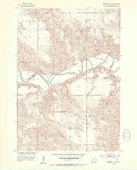
1951 Map of Presho 4 NE
USGS Topo · Published 1953About this map
White River carves a deep, winding valley through this South Dakota landscape, marking the natural boundary between Lyman and Tripp counties. At the time of this 1951 field check, the area remained largely rural and defined by its drainage basins and isolated community hubs. Evidence of mid-century prairie life is found in the placement of the Holy Rosary Church on the bluffs overlooking the river and the distribution of local education centers like Allyn School and North Greenwood School. The terrain is deeply dissected by numerous tributaries, including Mission Creek, Cottonwood Creek, and Dog Ear Creek, which dictate the placement of roads and homesteads across the townships of Sylvia and Greenwood. Small-scale industry is represented by a Gravel Pit, while the presence of a lone Well near the river highlights the essential nature of water resources in this arid environment.
Find a feature on this map
15 named features on this map. Tap any name to fly to it.
Don’t see what you’re looking for? This feature index may not catch every label — zoom into the map to look around manually.
Map Details
Editions of this 1951 Presho 4 NE Map
4 editions found
Other maps of this area

1951 · Presho 4 NE
USGS Topo · 1:24,000

1951 · Ideal NW
USGS Topo · 1:24,000

1951 · Presho 4 NW
USGS Topo · 1:24,000

1955 · Martin
USGS Topo · 1:250,000

1955 · Mitchell
USGS Topo · 1:250,000

1958 · Martin
USGS Topo · 1:250,000

1959 · Mitchell
USGS Topo · 1:250,000

1978 · Kennebec SW
USGS Topo · 1:24,000
1978 · Presho SE
USGS Topo · 1:24,000

1978 · Presho SW
USGS Topo · 1:24,000