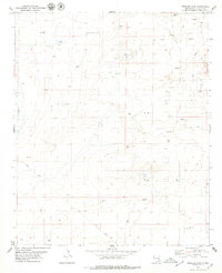
1978 Map of Presler Lake
USGS Topo · Published 1979About this map
The Cato Oil Field dominates the eastern edge of this Chaves County landscape, defined by a dense grid of extraction infrastructure including numerous Oil Wells and Gravel Pits. Water management is central to this arid region, evidenced by a series of catchment features such as Broke Tank, Cooper Tank, and the larger Broke Tank Lake. These man-made and natural catchments supported the local cattle industry, anchored by East Camp in the northern reaches of the quadrangle.
Find a feature on this map
13 named features on this map. Tap any name to fly to it.
Don’t see what you’re looking for? This feature index may not catch every label — zoom into the map to look around manually.
Map Details
Editions of this 1978 Presler Lake Map
2 editions found
Other maps of this area

1949 · Sardine Mountain
USGS Topo · 1:24,000

1954 · Brownfield
USGS Topo · 1:250,000

1955 · Roswell
USGS Topo · 1:250,000

1958 · Brownfield
USGS Topo · 1:250,000

1958 · Roswell
USGS Topo · 1:250,000

1962 · Roswell
USGS Topo · 1:250,000

1962 · Brownfield
USGS Topo · 1:250,000

1967 · Elkins
USGS Topo · 1:24,000
1967 · Sardine Lake
USGS Topo · 1:24,000
1973 · Oasis
USGS Topo · 1:24,000