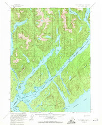
1955 Map of Prince Rupert D-2
USGS Topo · Published 1971About this map
The Alaska British Columbia Boundary cuts diagonally through this maritime landscape, tracing the waters of Pearse Canal and the United States Canada Boundary. This 1955 survey captures the complex archipelago of the Tongass National Forest, where deep fjords like Willard Inlet and Fillmore Inlet carve through high coastal peaks. A single Cannery at Gwent Cove represents the region's historical reliance on the salmon industry, situated near the northern reach of Pearse Canal.
Find a feature on this map
40 named features on this map. Tap any name to fly to it.
Don’t see what you’re looking for? This feature index may not catch every label — zoom into the map to look around manually.
Map Details
Editions of this 1955 Prince Rupert D-2 Map
2 editions found
Other maps of this area

1951 · Prince Rupert
USGS Topo · 1:250,000

1952 · Ketchikan
USGS Topo · 1:250,000

1955 · Ketchikan A-2
USGS Topo · 1:63,360

1955 · Prince Rupert D-3
USGS Topo · 1:63,360

1955 · Ketchikan A-1
USGS Topo · 1:63,360

1955 · Ketchikan A-3
USGS Topo · 1:63,360

1955 · Prince Rupert D-2
USGS Topo · 1:63,360
1955 · Prince Rupert D-1
USGS Topo · 1:63,360

1955 · Ketchikan
USGS Topo · 1:250,000
1958 · Prince Rupert C-2 and C-3
USGS Topo · 1:63,360