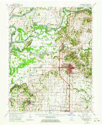
1959 Map of Princeton
USGS Topo · Published 1964About this map
Princeton serves as the industrial and transit hub of this 1959 landscape, where the Southern and Chicago And Eastern Illinois railroads converge. The map documents an intensive hydraulic engineering system designed to manage the flood-prone bottomlands where the Wabash River, White River, and Patoka River meet. Features like the Brevoort Levee and a dense network of drainage channels, including Mauck Ditch and Stormont Ditch, reveal the effort required to reclaim this fertile river junction for agriculture and settlement.
Find a feature on this map
86 named features on this map. Tap any name to fly to it.
Don’t see what you’re looking for? This feature index may not catch every label — zoom into the map to look around manually.
Map Details
Editions of this 1959 Princeton Map
2 editions found
Other maps of this area

1901 · Princeton
USGS Topo · 1:62,500

1901 · Haubstadt
USGS Topo · 1:62,500

1902 · Ditney
USGS Topo · 1:125,000

1902 · Boonville
USGS Topo · 1:62,500

1903 · Haubstadt
USGS Topo · 1:62,500

1903 · New Harmony
USGS Topo · 1:62,500

1903 · Petersburg
USGS Topo · 1:62,500

1903 · Princeton
USGS Topo · 1:62,500

1903 · Patoka
USGS Topo · 1:125,000

1904 · Mount Carmel
USGS Topo · 1:62,500