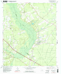
1979 Map of Pringletown
USGS Topo · Published 1992About this map
Four Hole Swamp dominates this Lowcountry landscape, its intricate network of waterways like Merkel Branch and Rock Branch cutting through the forested bottomlands along the Berkeley and Dorchester county line. The map reveals a community defined by its spiritual geography, featuring numerous rural houses of worship including Mt Pisgah Ch, House of God Ch, and Sand Ridge Ch. The settlement pattern centers on Pringletown, where the topography shifts from swampy basins to the slightly higher ground occupied by several sandpits.
Find a feature on this map
32 named features on this map. Tap any name to fly to it.
Don’t see what you’re looking for? This feature index may not catch every label — zoom into the map to look around manually.
Map Details
Editions of this 1979 Pringletown Map
3 editions found
Other maps of this area

1919 · Summerville
USGS Topo · 1:48,000

1919 · Ridgeville
USGS Topo · 1:48,000

1920 · Eutawville
USGS Topo · 1:48,000

1920 · Chicora
USGS Topo · 1:48,000

1920 · Ridgeville
USGS Topo · 1:62,500

1920 · Summerville
USGS Topo · 1:62,500

1921 · Chicora
USGS Topo · 1:62,500

1921 · Eutawville
USGS Topo · 1:62,500

1943 · Chicora
USGS Topo · 1:62,500

1943 · Ridgeville
USGS Topo · 1:62,500