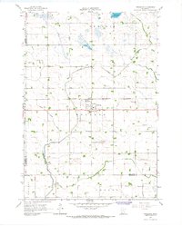
1965 Map of Prinsburg
USGS Topo · Published 1967About this map
Prinsburg is the central hub of this agricultural landscape in west-central Minnesota during the mid-1960s. The settlement is defined by the Chicago and North Western railroad line and a prominent Water Tank, serving as a localized point of industry and commerce amidst the surrounding townships of Holland and Edwards. The map reveals a highly managed hydrological system designed for prairie farming, dominated by an extensive network of drainage features such as Judicial Ditch No 31 and Ditch No 56, which feed into Chetomba Creek. For those tracing local heritage, the map identifies specific landmarks like School No 815 and the Holland Cem, providing precise locations for community centers that were vital to the rural population of Kandiyohi and Renville counties.
Find a feature on this map
21 named features on this map. Tap any name to fly to it.
Don’t see what you’re looking for? This feature index may not catch every label — zoom into the map to look around manually.
Map Details
Editions of this 1965 Prinsburg Map
This is the sole edition of this map. No revisions or reprints were ever made.
Other maps of this area

1953 · New Ulm
USGS Topo · 1:250,000

1953 · Saint Cloud
USGS Topo · 1:250,000

1957 · Saint Cloud
USGS Topo · 1:250,000

1957 · New Ulm
USGS Topo · 1:250,000

1958 · New Ulm
USGS Topo · 1:250,000

1958 · Saint Cloud
USGS Topo · 1:250,000

1958 · Kerkhoven SE
USGS Topo · 1:24,000

1958 · Raymond
USGS Topo · 1:24,000

1958 · Willmar
USGS Topo · 1:24,000

1965 · Danube
USGS Topo · 1:24,000