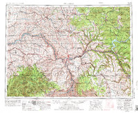
1955 Map of Pullman
USGS Topo · Published 1976About this map
The confluence of the Snake River and Clearwater River serves as the geographic anchor for this 1955 survey, revised in the mid-1970s. The map details the borderlands of Washington and Idaho, where the Palouse hills transition into the steep timberlands of the St Joe National Forest and Clearwater National Forest. The regional economy of the mid-20th century is clearly visible through the dense network of the Union Pacific RR, Northern Pacific RR, and the Camas Prairie RR, which served the grain-growing plateaus and timber stands. Higher elevations are marked by distinctive landmarks like Steptoe Butte and Moscow Mountain, while the southern reaches descend into the Nez Perce Indian Reservation. Significant infrastructure changes of the era are evident in the presence of the Dworshak Reservoir, illustrating the evolving management of the region's massive water systems for power and transit.
Find a feature on this map
68 named features on this map. Tap any name to fly to it.
Don’t see what you’re looking for? This feature index may not catch every label — zoom into the map to look around manually.
Map Details
Editions of this 1955 Pullman Map
3 editions found

Other maps of this area

1903 · Oakesdale
USGS Topo · 1:125,000

1905 · Oakesdale
USGS Topo · 1:125,000

1910 · Pullman
USGS Topo · 1:125,000

1914 · Avery
USGS Topo · 1:125,000

1917 · Avery
USGS Topo · 1:125,000

1919 · Walla Walla
USGS Topo · 1:125,000

1921 · Walla Walla
USGS Topo · 1:125,000

1923 · Washington Creek
USGS Topo · 1:125,000

1924 · Kamiah
USGS Topo · 1:125,000

1924 · Weippe
USGS Topo · 1:125,000