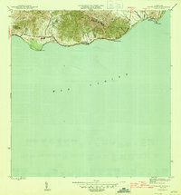
1945 Map of Punta Tuna
USGS Topo · Published 1945About this map
The southeastern coastline of Puerto Rico is dominated by the Sierra de Guardarrayas and the prominent headland of Pta Tuna. This mid-century survey reveals a coastal landscape defined by the agricultural footprint of Hacienda San Isidro and the maritime importance of the Faro lighthouse standing sentinel over the Mar de Antillas. The inland areas show the Municipio de Maunabo boundary, where numerous streams like Quebrada Arenas and Quebrada Florida descend from the ridges toward the sea.
Find a feature on this map
20 named features on this map. Tap any name to fly to it.
Don’t see what you’re looking for? This feature index may not catch every label — zoom into the map to look around manually.
Map Details
Editions of this 1945 Punta Tuna Map
4 editions found
Other maps of this area

1945 · Punta Tuna
USGS Topo · 1:30,000

1946 · Patillas
USGS Topo · 1:30,000

1946 · Punta Guayanes
USGS Topo · 1:30,000

1946 · Yabucoa
USGS Topo · 1:30,000

1946 · Guayama
USGS Topo · 1:30,000

1947 · Yabucoa SO
USGS Topo · 1:10,000
1947 · Guayama NE
USGS Topo · 1:10,000
1947 · Punta Tuna NO
USGS Topo · 1:10,000
1947 · Yabucoa SE
USGS Topo · 1:10,000
1947 · Patillas SE
USGS Topo · 1:10,000
Featured Places
- Barro Blanco, Patillas
- Sector María Marisca, Patillas
- Sector Bordaleza, Maunabo
- Sector Higuero, Patillas
- Maunabo