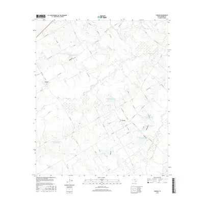
2016 Map of Purdon
USGS Topo · Published 2016About this map
Purdon and Pursley serve as the primary nodes of settlement in this Navarro County landscape, where the rural character is defined by an extensive system of water management. Numerous reservoirs, such as the Soil Conservation Service Site 129 Reservoir and Soil Conservation Service Site 118 Reservoir, are distributed across the drainage basins of Richland Cr and its tributaries. These sites, along with others like Carroll Lake, indicate a mid-to-late 20th-century focus on flood control and soil stabilization in this agricultural region. The network of local roads, including FM 709 S and various county routes like SW Co Rd 3010, connects the scattered farms and homesteads. Small waterways like Hughes Br, Melton Br, and Pin Oak Cr lace through the terrain, illustrating the intricate natural drainage that necessitates the extensive Soil Conservation Service infrastructure visible throughout the quadrangle.
Find a feature on this map
67 named features on this map. Tap any name to fly to it.
Don’t see what you’re looking for? This feature index may not catch every label — zoom into the map to look around manually.
Map Details
Editions of this 2016 Purdon Map
This is the sole edition of this map. No revisions or reprints were ever made.
Other maps of this area

1954 · Dallas
USGS Topo · 1:250,000

1954 · Waco
USGS Topo · 1:250,000

1955 · Waco
USGS Topo · 1:250,000

1956 · Dawson
USGS Topo · 1:24,000

1958 · Dallas
USGS Topo · 1:250,000

1963 · Richland
USGS Topo · 1:24,000

1963 · Wortham
USGS Topo · 1:24,000
1965 · Corsicana
USGS Topo · 1:24,000

1965 · Coolidge
USGS Topo · 1:24,000
1965 · Blooming Grove
USGS Topo · 1:24,000