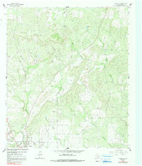
1962 Map of Purdy Hill
USGS Topo · Published 1991About this map
The Mason Mountains dominate the northern landscape of this Texas Hill Country quadrangle, where the rugged terrain transitions into a valley network defined by Comanche Creek and Little Willow Creek. In the early 1960s, the town of Mason and the smaller settlement of Kooksville anchored the southwestern corner, serving as a hub for the surrounding ranching and quarrying operations. The map reveals an intensive pattern of family-named burial grounds across the rural landscape, including Behrens Cem, Polk Cem, and the Old Gooch Cem, which provide significant genealogical clues for the region. Industrial activity is visible through scattered Quarry and Gravel Pits sites, while landmarks like the Purdy Hill summit and Bullhead Tank serve as distinctive reference points in this high-relief terrain.
Find a feature on this map
32 named features on this map. Tap any name to fly to it.
Don’t see what you’re looking for? This feature index may not catch every label — zoom into the map to look around manually.
Map Details
Editions of this 1962 Purdy Hill Map
2 editions found
Other maps of this area

1887 · Mason
USGS Topo · 1:125,000

1894 · Mason
USGS Topo · 1:125,000

1954 · Llano
USGS Topo · 1:250,000

1955 · Llano
USGS Topo · 1:250,000

1956 · Llano
USGS Topo · 1:250,000

1962 · Purdy Hill
USGS Topo · 1:24,000
1962 · Fly Gap
USGS Topo · 1:24,000
1962 · Fredonia
USGS Topo · 1:24,000

1963 · Spy Rock
USGS Topo · 1:24,000
1967 · Art
USGS Topo · 1:24,000