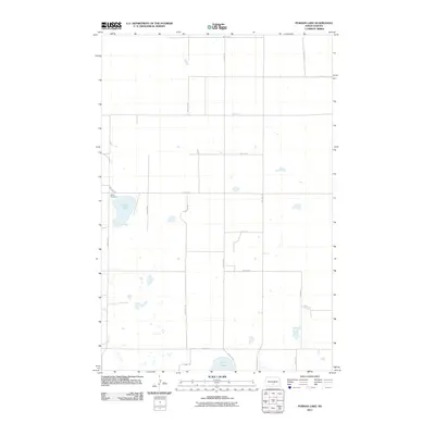
2011 Map of Pursian Lake
USGS Topo · Published 2011About this map
Bethel Cemetery sits on a small rise overlooking a landscape defined by prairie potholes and glacial depressions in the early twenty-first century. This portion of Logan County is characterized by a stark, rectilinear grid of rural routes, including 50th St SE and 22nd Ave SE, which segment the terrain into large agricultural blocks. The natural hydrology is dominated by significant water bodies such as Pursian Lake and Stink Lake, along with numerous smaller, unnamed seasonal wetlands. The sparse distribution of named sites reflects the open, low-density settlement pattern of the region, where a single cemetery or lake serves as a primary waypoint for miles across the plains.
Find a feature on this map
19 named features on this map. Tap any name to fly to it.
Don’t see what you’re looking for? This feature index may not catch every label — zoom into the map to look around manually.
Map Details
Editions of this 2011 Pursian Lake Map
This is the sole edition of this map. No revisions or reprints were ever made.
Other maps of this area

1951 · Driscoll
USGS Topo · 1:62,500

1952 · Dawson
USGS Topo · 1:24,000

1952 · Steele
USGS Topo · 1:24,000

1953 · Jamestown
USGS Topo · 1:250,000

1954 · Bismarck
USGS Topo · 1:250,000

1956 · Jamestown
USGS Topo · 1:250,000

1958 · Bismarck
USGS Topo · 1:250,000

1975 · Lake Geneva
USGS Topo · 1:24,000

1975 · Braddock
USGS Topo · 1:24,000
1975 · Braddock NE
USGS Topo · 1:24,000