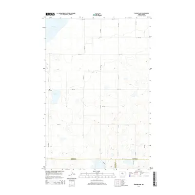
2014 Map of Pursian Lake
USGS Topo · Published 2014About this map
Pursian Lake and the southern reaches of Long Lake define this prairie landscape along the intersection of Kidder, Emmons, and Logan counties. The 2014 survey captures a sparsely populated region of the North Dakota plains, where the section-line road grid—including 22nd Ave SE and 50th St SE—organizes the agricultural terrain. A significant site for local history is the Bethel Cem, located west of Pursian Lake. The map reveals a high concentration of small, unnamed wetlands and prairie potholes typical of the Missouri Coteau region, highlighting the complex drainage patterns that dominate this rural area at the tri-county corner.
Find a feature on this map
23 named features on this map. Tap any name to fly to it.
Don’t see what you’re looking for? This feature index may not catch every label — zoom into the map to look around manually.
Map Details
Editions of this 2014 Pursian Lake Map
This is the sole edition of this map. No revisions or reprints were ever made.
Other maps of this area

1951 · Driscoll
USGS Topo · 1:62,500

1952 · Dawson
USGS Topo · 1:24,000

1952 · Steele
USGS Topo · 1:24,000

1953 · Jamestown
USGS Topo · 1:250,000

1954 · Bismarck
USGS Topo · 1:250,000

1956 · Jamestown
USGS Topo · 1:250,000

1958 · Bismarck
USGS Topo · 1:250,000

1975 · Lake Geneva
USGS Topo · 1:24,000

1975 · Braddock
USGS Topo · 1:24,000
1975 · Braddock NE
USGS Topo · 1:24,000