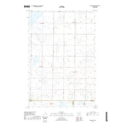
2018 Map of Pursian Lake
USGS Topo · Published 2018About this map
Pursian Lake and a series of smaller prairie wetlands define this rural landscape at the junction of Kidder, Emmons, and Logan counties. The terrain is structured by the Public Land Survey System, with a regular grid of section lines and gravel roads including 50th St SE and 24th Ave SE. This late-2010s survey shows the sparse development of the North Dakota plains, where the Bethel Cem stands as a primary landmark for local history and genealogy research. In the northern reaches, the edge of Long Lake enters the frame, while Stink Lake sits near the southern boundary. The map provides a clear view of the drainage patterns and township boundaries, including t137n r74w, which govern the agricultural character of this central North Dakota region.
Find a feature on this map
30 named features on this map. Tap any name to fly to it.
Don’t see what you’re looking for? This feature index may not catch every label — zoom into the map to look around manually.
Map Details
Editions of this 2018 Pursian Lake Map
This is the sole edition of this map. No revisions or reprints were ever made.
Other maps of this area

1951 · Driscoll
USGS Topo · 1:62,500

1952 · Dawson
USGS Topo · 1:24,000

1952 · Steele
USGS Topo · 1:24,000

1953 · Jamestown
USGS Topo · 1:250,000

1954 · Bismarck
USGS Topo · 1:250,000

1956 · Jamestown
USGS Topo · 1:250,000

1958 · Bismarck
USGS Topo · 1:250,000

1975 · Lake Geneva
USGS Topo · 1:24,000

1975 · Braddock
USGS Topo · 1:24,000
1975 · Braddock NE
USGS Topo · 1:24,000