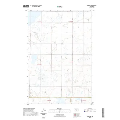
2020 Map of Pursian Lake
USGS Topo · Published 2020About this map
Pursian Lake and its surrounding wetlands dominate this prairie landscape at the intersection of Kidder, Emmons, and Logan counties. The 2020 survey reveals a sparse settlement pattern characteristic of the Great Plains, where section lines dictate the road network of routes like 22nd Ave SE and 50th St SE. A significant point of local history is found at Bethel Cem, situated west of the namesake lake. The terrain is defined by numerous smaller water bodies and depressions, including Long Lake to the north and Stink Lake along the southern boundary line. This map captures the region's enduring rural character, illustrating the vast open spaces and hydrological features that have influenced land use and travel in this portion of North Dakota for generations.
Find a feature on this map
29 named features on this map. Tap any name to fly to it.
Don’t see what you’re looking for? This feature index may not catch every label — zoom into the map to look around manually.
Map Details
Editions of this 2020 Pursian Lake Map
This is the sole edition of this map. No revisions or reprints were ever made.
Other maps of this area

1951 · Driscoll
USGS Topo · 1:62,500

1952 · Dawson
USGS Topo · 1:24,000

1952 · Steele
USGS Topo · 1:24,000

1953 · Jamestown
USGS Topo · 1:250,000

1954 · Bismarck
USGS Topo · 1:250,000

1956 · Jamestown
USGS Topo · 1:250,000

1958 · Bismarck
USGS Topo · 1:250,000

1975 · Lake Geneva
USGS Topo · 1:24,000

1975 · Braddock
USGS Topo · 1:24,000
1975 · Braddock NE
USGS Topo · 1:24,000