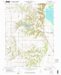
1972 Map of Putnam
USGS Topo · Published 1974About this map
Putnam occupies a narrow terrace between the steep, dissected bluffs and the broad Illinois River bottomlands in the early 1970s. The landscape is defined by the sharp transition from the upland prairies of Wheatland and Whitefield to the alluvial plains of Goose Lake and Senachwine Lake. Significant water management and recreation are evident at Lake Thunderbird, where a spillway and the nearby St Joseph Cem mark the intersection of modern development and older local landmarks.
Find a feature on this map
23 named features on this map. Tap any name to fly to it.
Don’t see what you’re looking for? This feature index may not catch every label — zoom into the map to look around manually.
Map Details
Editions of this 1972 Putnam Map
2 editions found
Other maps of this area

1893 · Lacon
USGS Topo · 1:62,500

1893 · Hennepin
USGS Topo · 1:62,500

1909 · Hennepin
USGS Topo · 1:62,500

1911 · Hennepin
USGS Topo · 1:62,500

1921 · Buda
USGS Topo · 1:62,500

1923 · Buda
USGS Topo · 1:62,500

1933 · Lacon
USGS Topo · 1:62,500

1933 · Camp Grove
USGS Topo · 1:48,000

1937 · Lacon
USGS Topo · 1:62,500

1945 · Bradford
USGS Topo · 1:62,500