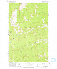
1969 Map of Pyramid Peak
USGS Topo · Published 1978About this map
Kaniksu National Forest defines this high-elevation landscape in Boundary County, where a network of trails and primitive routes connect remote peaks and glacial lakes. The 1969 field-checked data shows a terrain dominated by significant massifs like Pyramid Peak and Parker Peak, which rise above a series of drainages including Trout Creek and Fisher Creek. The southern portion of the sheet is largely occupied by the Myrtle Creek State Game Preserve, an area managed for wildlife protection at the time of this survey. Notable water features like Big Fisher Lake, Pyramid Lake, and Ball Lakes are positioned among the ridges, often accessible only via a pack trail. This map captures the administrative and natural boundaries of the Idaho panhandle's backcountry during the late 1960s, documenting the drainage patterns of Spanish Creek, Finn Creek, and Dutch Creek as they flow from the high divides of Russell Ridge.
Find a feature on this map
37 named features on this map. Tap any name to fly to it.
Don’t see what you’re looking for? This feature index may not catch every label — zoom into the map to look around manually.
Map Details
Editions of this 1969 Pyramid Peak Map
2 editions found

Other maps of this area

1911 · Priest Lake
USGS Topo · 1:250,000

1913 · Priest Lake
USGS Topo · 1:250,000

1958 · Sandpoint
USGS Topo · 1:250,000

1963 · Sandpoint
USGS Topo · 1:250,000

1965 · Farnham Peak
USGS Topo · 1:24,000

1965 · Moravia
USGS Topo · 1:24,000

1965 · Copeland
USGS Topo · 1:24,000

1967 · The Wigwams
USGS Topo · 1:24,000
1967 · Roman Nose
USGS Topo · 1:24,000

1968 · Smith Falls
USGS Topo · 1:24,000