
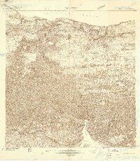
1938 Map of Quebradillas
USGS Topo · Published 1938About this map
Quebradillas serves as the focal point of this late 1930s survey, situated along the northern coast where the American Porto Rico railroad traces the shoreline. The landscape is defined by the deep carving of the Rio Guajataca, which forms a prominent boundary through the center of the sheet. An exceptional density of educational sites is recorded, with dozens of rural schools such as Escuela Horatio Mann Towner and Escuela Rafael Cordero scattered throughout the interior hills. The mapping of religious landmarks like Iglesia Virgen del Carmen and Capilla San Antonio provides valuable data for genealogists tracing community centers in the Municipio de Quebradillas. Coastal geography is detailed through terrain markers like Monte de la Luz and the irrigation infrastructure of Desvio Riego, reflecting the agrarian and civic organization of the era.
Find a feature on this map
52 named features on this map. Tap any name to fly to it.
Don’t see what you’re looking for? This feature index may not catch every label — zoom into the map to look around manually.
Map Details
Editions of this 1938 Quebradillas Map
2 editions found
Other maps of this area

1937 · Moca
USGS Topo · 1:20,000

1938 · Alto Sano
USGS Topo · 1:20,000

1938 · Camuy
USGS Topo · 1:20,000

1938 · San Sebastian
USGS Topo · 1:20,000

1941 · Moca
USGS Topo · 1:30,000

1941 · Isabela
USGS Topo · 1:30,000

1941 · San Sebastian
USGS Topo · 1:30,000

1942 · Moca
USGS Topo · 1:30,000

1942 · Central La Plata
USGS Topo · 1:30,000

1942 · Camuy
USGS Topo · 1:30,000
Featured Places
- Quebradillas
- Reparto Apolonio Vélez Ramos, Isabela
- Villa Ledumerced, Quebradillas
- Hacienda La Sabana, Camuy
- Brisas de la Sabana, Camuy