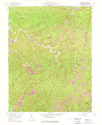
1958 Map of Quick
USGS Topo · Published 1977About this map
Quick sits at the confluence of several mountain branches, serving as a focal point for a landscape defined by narrow hollows and ridge-line industry. This mid-century survey reveals the deep integration of resource extraction and community life in Kanawha County, where numerous small settlements like Blount and Cinco are linked by the Conrail line and winding valley roads. The map highlights the educational and spiritual infrastructure of the era, from the Hansel Sch and Tenmile Sch to the Grace Ch, illustrating the social fabric of these rural coal and timber areas. Industrial activity is pervasive, marked by several mines and the Mt Desert Lookout Tower standing watch over the high ridges. Modernization is visible through photorevisions showing updated infrastructure like the Pumping Station and the sprawling Witcher Creek drainage, where oil wells and substations dot the terrain alongside older homesteads.
Find a feature on this map
49 named features on this map. Tap any name to fly to it.
Don’t see what you’re looking for? This feature index may not catch every label — zoom into the map to look around manually.
Map Details
Editions of this 1958 Quick Map
4 editions found
Other maps of this area

1897 · Kanawha Falls
USGS Topo · 1:125,000

1899 · Charleston
USGS Topo · 1:125,000

1900 · Kanawha Falls
USGS Topo · 1:125,000

1901 · Kanawha Falls
USGS Topo · 1:125,000

1907 · Clendenin
USGS Topo · 1:62,500

1908 · Montgomery
USGS Topo · 1:48,000

1909 · Charleston
USGS Topo · 1:62,500

1909 · Clendenin
USGS Topo · 1:62,500

1909 · Peytona
USGS Topo · 1:48,000

1910 · Montgomery
USGS Topo · 1:62,500