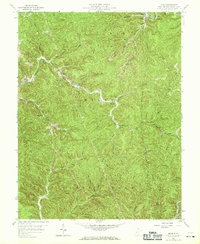
1958 Map of Quick
USGS Topo · Published 1969About this map
The rugged topography of Kanawha County is defined here by the winding course of Blue Creek and its many tributaries, such as Fivemile Creek and Eightmile Fork. In the late 1950s, the landscape was a mosaic of coal-country settlements and rural infrastructure. Small communities like Quick, Coalridge, and Putney are tucked into the narrow valleys, connected by a network of unimproved roads and light-duty paths. The presence of numerous labeled Mine locations and extensive Pipeline networks underscores the region's industrial reliance on resource extraction during this era.
Find a feature on this map
56 named features on this map. Tap any name to fly to it.
Don’t see what you’re looking for? This feature index may not catch every label — zoom into the map to look around manually.
Map Details
Editions of this 1958 Quick Map
4 editions found
Other maps of this area

1897 · Kanawha Falls
USGS Topo · 1:125,000

1899 · Charleston
USGS Topo · 1:125,000

1900 · Kanawha Falls
USGS Topo · 1:125,000

1901 · Kanawha Falls
USGS Topo · 1:125,000

1907 · Clendenin
USGS Topo · 1:62,500

1908 · Montgomery
USGS Topo · 1:48,000

1909 · Charleston
USGS Topo · 1:62,500

1909 · Clendenin
USGS Topo · 1:62,500

1909 · Peytona
USGS Topo · 1:48,000

1910 · Montgomery
USGS Topo · 1:62,500