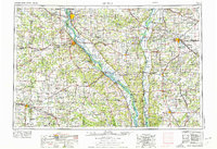
1956 Map of Quincy
USGS Topo · Published 1976About this map
The Mississippi River corridor serves as the primary artery for this mid-century survey, dividing the Illinois and Missouri landscapes. Major riverfront settlements like Quincy and Hannibal anchor the regional trade network, while the convergence of the Illinois River and Missouri River further south highlights the era's reliance on these massive waterways. Inland, the map reveals a dense agricultural and transit grid, featuring significant educational landmarks such as Culver-Stockton College and Illinois College.
Find a feature on this map
114 named features on this map. Tap any name to fly to it.
Don’t see what you’re looking for? This feature index may not catch every label — zoom into the map to look around manually.
Map Details
Editions of this 1956 Quincy Map
3 editions found

Other maps of this area

1886 · Jefferson City
USGS Topo · 1:125,000

1890 · Louisiana
USGS Topo · 1:125,000

1890 · Mexico
USGS Topo · 1:125,000

1890 · Moberly
USGS Topo · 1:125,000

1890 · Hermann
USGS Topo · 1:125,000

1890 · Fulton
USGS Topo · 1:125,000

1894 · Jefferson City
USGS Topo · 1:125,000

1903 · O'Fallon
USGS Topo · 1:125,000

1903 · Kahoka
USGS Topo · 1:125,000

1903 · Palmyra
USGS Topo · 1:125,000