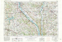
1956 Map of Quincy
USGS Topo · Published 1980About this map
The Mississippi River and Illinois River corridors define this regional landscape, serving as the primary arteries for commerce and settlement across western Illinois and northeastern Missouri. By 1980, the river economy is complemented by a dense rail network, including the Burlington Northern and Norfolk and Western lines that connect established river towns like Quincy and Hannibal to interior agricultural hubs such as Jacksonville and Mexico. Conservation efforts are evident in the numerous protected wetlands along the river bottoms, such as the Clarence Cannon National Wildlife Refuge and Meredosia National Wildlife Refuge. Further inland, the map documents the character of the Pike County Hills and Calhoun County Hills, where smaller communities like Pittsfield and Jerseyville serve as centers for the surrounding rural counties.
Find a feature on this map
321 named features on this map. Tap any name to fly to it.
Don’t see what you’re looking for? This feature index may not catch every label — zoom into the map to look around manually.
Map Details
Editions of this 1956 Quincy Map
3 editions found

Other maps of this area

1886 · Jefferson City
USGS Topo · 1:125,000

1890 · Louisiana
USGS Topo · 1:125,000

1890 · Mexico
USGS Topo · 1:125,000

1890 · Moberly
USGS Topo · 1:125,000

1890 · Hermann
USGS Topo · 1:125,000

1890 · Fulton
USGS Topo · 1:125,000

1894 · Jefferson City
USGS Topo · 1:125,000

1903 · O'Fallon
USGS Topo · 1:125,000

1903 · Kahoka
USGS Topo · 1:125,000

1903 · Palmyra
USGS Topo · 1:125,000