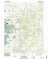
1995 Map of Quincy East
USGS Topo · Published 1998About this map
The expanding eastern residential corridors of Quincy meet the rural townships of Ellington and Melrose in this mid-1990s topographical survey. The landscape is notably dense with commemorative and family sites, including the National Cem, St Peters Cem, and Laughlin Cem. Beyond the city grid along College Ave and Maine St, the terrain is defined by the winding paths of Mill Creek and Cedar Creek, where small settlements like Ewbanks and Hickory Grove mark the transition to open Illinois farmland. A distinct Quarry sits near the center of the map, illustrating local extractive industry alongside natural features like Ward Spring and the evocative Ghost Hollow to the southwest. The presence of numerous Mobile Home Parks and several Comm Towers indicates the late-century infrastructure and population shifts occurring just east of the city core.
Find a feature on this map
41 named features on this map. Tap any name to fly to it.
Don’t see what you’re looking for? This feature index may not catch every label — zoom into the map to look around manually.
Map Details
Editions of this 1995 Quincy East Map
This is the sole edition of this map. No revisions or reprints were ever made.
Other maps of this area

1925 · Quincy
USGS Topo · 1:62,500

1925 · Liberty
USGS Topo · 1:62,500

1927 · Liberty
USGS Topo · 1:62,500

1944 · Quincy
USGS Topo · 1:62,500

1945 · Quincy
USGS Topo · 1:62,500

1946 · Mendon
USGS Topo · 1:62,500

1948 · Quincy
USGS Topo · 1:250,000

1948 · Mendon
USGS Topo · 1:62,500

1948 · Camp Point
USGS Topo · 1:62,500

1956 · Quincy
USGS Topo · 1:250,000