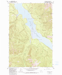
1958 Map of Quintonkon
USGS Topo · Published 1991About this map
Hungry Horse Reservoir South Fork Flathead River dominates the center of this 1958 survey, showing the landscape as it appeared shortly after the reservoir's creation. The map documents early recreational and engineering infrastructure within the Flathead National Forest, including the Devils Corkscrew Campground and Peters Creek Campground. A notable detail for industrial historians is the notation of Core Drill Holes on the eastern shore near Corkscrew Creek, likely related to the geological assessments for the massive dam project downstream.
Find a feature on this map
30 named features on this map. Tap any name to fly to it.
Don’t see what you’re looking for? This feature index may not catch every label — zoom into the map to look around manually.
Map Details
Editions of this 1958 Quintonkon Map
4 editions found
Other maps of this area

1914 · Nyack
USGS Topo · 1:125,000

1955 · Choteau
USGS Topo · 1:250,000

1957 · Choteau
USGS Topo · 1:250,000

1958 · Choteau
USGS Topo · 1:250,000

1958 · Circus Peak
USGS Topo · 1:24,000

1958 · Nimrod
USGS Topo · 1:24,000

1958 · Quintonkon
USGS Topo · 1:24,000

1958 · Felix Peak
USGS Topo · 1:24,000

1960 · Cut Bank
USGS Topo · 1:250,000

1962 · Choteau
USGS Topo · 1:250,000