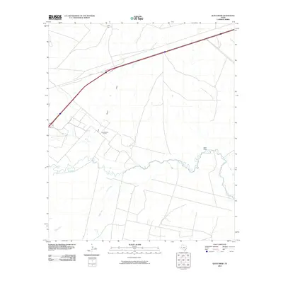
2010 Map of Quito Draw
USGS Topo · Published 2010About this map
The meandering Pecos River carves a winding path through this West Texas landscape, serving as a primary geographical anchor in a region defined by its drainage basins and industrial development. Local water systems including Toyah Creek and the namesake Quito Draw converge toward the river, illustrating the complex hydrology of the Reeves County desert floor. The influence of the regional petroleum industry is evidenced by the Scott Delaware Oil Field, which sits in the shadow of topographic rises like Hays Hill. Transportation infrastructure is dominated by the diagonal corridor of I-20b Bus, which cuts across the northern half of the quadrangle, linking the open range to larger transit networks. For those tracking the evolution of Texas land use, this survey documents the persistent relationship between modern energy extraction and the natural landmarks like Rock Quarry Draw that have long defined the territory.
Find a feature on this map
8 named features on this map. Tap any name to fly to it.
Don’t see what you’re looking for? This feature index may not catch every label — zoom into the map to look around manually.
Map Details
Editions of this 2010 Quito Draw Map
This is the sole edition of this map. No revisions or reprints were ever made.
Other maps of this area

1931 · Barstow
USGS Topo · 1:125,000

1954 · Pecos
USGS Topo · 1:250,000

1957 · Pecos
USGS Topo · 1:250,000

1961 · Soda Lake
USGS Topo · 1:24,000

1963 · Ligon Ranch
USGS Topo · 1:24,000

1963 · Old X Ranch
USGS Topo · 1:24,000

1963 · Quito Draw
USGS Topo · 1:24,000

1963 · China Lake
USGS Topo · 1:24,000

1963 · Pecos East
USGS Topo · 1:24,000

1963 · Toyah Lake
USGS Topo · 1:24,000