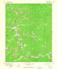
1965 Map of Racine
USGS Topo · Published 1966About this map
The Coal River and Big Coal River wind through this mid-1960s survey of southern West Virginia, tracing a landscape defined by the extraction of natural resources. The industrial character of the region is evident in the prevalence of numerous Strip Mines and the presence of a Compressor Station and Gaging Station along the river banks. Transportation for the local mining economy is provided by the Chesapeake and Ohio railroad, which parallels the water through settlements like Peytona and Racine.
Find a feature on this map
98 named features on this map. Tap any name to fly to it.
Don’t see what you’re looking for? This feature index may not catch every label — zoom into the map to look around manually.
Map Details
Editions of this 1965 Racine Map
3 editions found
Other maps of this area

1899 · Charleston
USGS Topo · 1:125,000

1909 · Charleston
USGS Topo · 1:62,500

1909 · Peytona
USGS Topo · 1:48,000

1909 · Saint Albans
USGS Topo · 1:62,500

1911 · Peytona
USGS Topo · 1:62,500

1911 · Madison
USGS Topo · 1:62,500

1929 · Madison
USGS Topo · 1:62,500

1929 · Peytona
USGS Topo · 1:62,500

1931 · Madison
USGS Topo · 1:62,500

1931 · Saint Albans
USGS Topo · 1:62,500