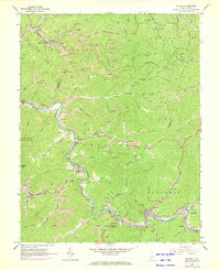
1965 Map of Racine
USGS Topo · Published 1972About this map
Coal and timber interests define this mid-1960s landscape along the winding Coal River on the border of Kanawha and Boone Counties. The Chesapeake and Ohio railroad serves numerous industrial sites, including a tipple, substation, and a compressor station at Brushton. The area is densely punctuated by strip mines that trace the contour lines of the steep ridges. Small riverside settlements like Peytona and Racine are centers of community life, while more secluded hollows are marked by family-named burial grounds such as Snodgrass Cem and Barker Cem. Public lands offer a contrast to the industrial activity, with the southern reaches of the Kanawha State Forest and the Fork Creek State Public Hunting Area preserving the heavily wooded terrain. Recreational stops like Drawdy Falls Roadside Park provide accessible points of interest along the main transit corridors.
Find a feature on this map
103 named features on this map. Tap any name to fly to it.
Don’t see what you’re looking for? This feature index may not catch every label — zoom into the map to look around manually.
Map Details
Editions of this 1965 Racine Map
3 editions found
Other maps of this area

1899 · Charleston
USGS Topo · 1:125,000

1909 · Charleston
USGS Topo · 1:62,500

1909 · Peytona
USGS Topo · 1:48,000

1909 · Saint Albans
USGS Topo · 1:62,500

1911 · Peytona
USGS Topo · 1:62,500

1911 · Madison
USGS Topo · 1:62,500

1929 · Madison
USGS Topo · 1:62,500

1929 · Peytona
USGS Topo · 1:62,500

1931 · Madison
USGS Topo · 1:62,500

1931 · Saint Albans
USGS Topo · 1:62,500