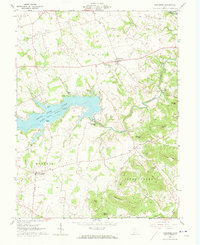
1961 Map of Rainsboro
USGS Topo · Published 1973About this map
Rocky Fork Lake State Park dominates the central landscape of this Highland County region, where the reservoir meets the winding waters of the Rocky Fork. The surrounding terrain is a mixture of agricultural uplands and steep, wooded ridges such as McCoppin Hill and Irons Mtn, revealing a landscape heavily shaped by local watercourses. Small settlements like Rainsboro and Marshall serve as rural hubs, while the map preserves the locations of numerous historic industrial sites including McCoppin Mill, Beaver Mill, and a Factory branch near Barretts Mills. Genealogy is well-represented through family-named landmarks and cemeteries like Hicksite Cem, Hartman Cem, and Butlers Cem. Notable cultural sites such as the Covered Bridge and the Fort Hill Youth Camp provide a clear view of the recreational and infrastructure developments present in the early 1960s.
Find a feature on this map
55 named features on this map. Tap any name to fly to it.
Don’t see what you’re looking for? This feature index may not catch every label — zoom into the map to look around manually.
Map Details
Editions of this 1961 Rainsboro Map
4 editions found
Other maps of this area

1915 · Bainbridge
USGS Topo · 1:48,000

1917 · Bainbridge
USGS Topo · 1:62,500

1917 · Greenfield
USGS Topo · 1:62,500

1917 · Hillsboro
USGS Topo · 1:62,500

1917 · Sabina
USGS Topo · 1:62,500

1943 · Sabina
USGS Topo · 1:62,500

1944 · Hillsboro
USGS Topo · 1:62,500

1944 · Greenfield
USGS Topo · 1:62,500

1947 · Columbus
USGS Topo · 1:250,000

1960 · Greenfield
USGS Topo · 1:24,000