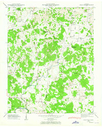
1947 Map of Rally Hill
USGS Topo · Published 1965About this map
The Lewisburg and Franklin Pike serves as a primary north-south artery through this Middle Tennessee landscape, crossing the boundaries of Williamson, Maury, and Marshall counties. At the time of this 1947 field examination, the area is defined by small agricultural hubs like Rally Hill and Pottsville, where local education and faith centered on sites such as Lee Buckner Sch and Old Lasea Ch. The terrain is shaped by the meandering Duck River in the south, creating the prominent Jones Bend and receiving waters from Pumpkin Creek and Flat Creek. Numerous family names are preserved across the map in the high density of small burial grounds, including the Derryberry Cem and Reynolds Cem, and local landmarks like Lunns Store and Reeds Store. The presence of Beer Wallow and several distinct hills such as Collins Hill and Orchard Hill suggests a landscape of varied elevation used for both farming and pasture.
Find a feature on this map
100 named features on this map. Tap any name to fly to it.
Don’t see what you’re looking for? This feature index may not catch every label — zoom into the map to look around manually.
Map Details
Editions of this 1947 Rally Hill Map
4 editions found
Other maps of this area

1909 · Franklin
USGS Topo · 1:62,500

1936 · Chapel Hill
USGS Topo · 1:24,000

1936 · Farmington
USGS Topo · 1:24,000

1936 · Verona
USGS Topo · 1:24,000

1936 · Rally Hill
USGS Topo · 1:24,000

1936 · Spring Hill
USGS Topo · 1:24,000

1936 · Carters Creek
USGS Topo · 1:24,000

1936 · Glendale
USGS Topo · 1:24,000

1936 · Bethesda
USGS Topo · 1:24,000

1941 · Carters Creek
USGS Topo · 1:24,000