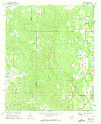
1970 Map of Ralph
USGS Topo · Published 1972About this map
The boundary between Greene and Tuscaloosa Counties runs through this rural landscape, which is defined by a dense network of creek drainages and small community centers. Small settlements like Ralph and Snoddy anchor the region, connected by winding country roads and the established Freeman Line. The area's social history is recorded through its many small churches and cemeteries, such as Mt Herman Ch and its associated Mt Herman Cem, as well as Wesley Chapel and the Old Bethel Cem. Terrain features like Reed Swamp and the elevations near the Lookout Ralph Tower provide a look at the natural landscape before modern expansion, while a road marked as Under Construction in the southern portion of the map indicates a moment of infrastructure growth in the early 1970s.
Find a feature on this map
33 named features on this map. Tap any name to fly to it.
Don’t see what you’re looking for? This feature index may not catch every label — zoom into the map to look around manually.
Map Details
Editions of this 1970 Ralph Map
2 editions found
Other maps of this area

1924 · Tuscaloosa
USGS Topo · 1:62,500

1926 · Tuscaloosa
USGS Topo · 1:62,500

1927 · Eutaw
USGS Topo · 1:48,000

1931 · Eutaw
USGS Topo · 1:62,500

1953 · Montgomery
USGS Topo · 1:250,000

1953 · Birmingham
USGS Topo · 1:250,000

1956 · Birmingham
USGS Topo · 1:250,000

1956 · Montgomery
USGS Topo · 1:250,000

1957 · Birmingham
USGS Topo · 1:250,000

1957 · Montgomery
USGS Topo · 1:250,000