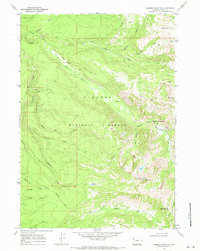
1968 Map of Rammel Mountain
USGS Topo · Published 1971About this map
Targhee National Forest dominates this 1960s landscape in Teton County, defined by a complex network of pack trails and watercourses. The high elevations of Rammel Mountain and Mount Nord overlook deep drainage systems including Bitch Creek and its various forks. The map reveals a wild territory managed for both conservation and transit, with specific pathways like the Poacher Trail and Camp Lake Tr providing access to remote points like Hidden Corral Basin. The presence of the Jackpine Loop Rd in the southwest corner suggests the limited reach of vehicular access compared to the extensive Pack Trail system that traverses Carrot Ridge and Dry Ridge. Notable natural landmarks such as the Bitch Creek Narrows and Indian Meadows mark significant points in the topography where the landscape shifts from steep ridges to narrow canyons and open clearings.
Find a feature on this map
38 named features on this map. Tap any name to fly to it.
Don’t see what you’re looking for? This feature index may not catch every label — zoom into the map to look around manually.
Map Details
Editions of this 1968 Rammel Mountain Map
3 editions found
Other maps of this area

1886 · Shoshone
USGS Topo · 1:125,000

1888 · Shoshone
USGS Topo · 1:125,000

1895 · Shoshone
USGS Topo · 1:125,000

1899 · Grand Teton
USGS Topo · 1:125,000

1901 · Shoshone
USGS Topo · 1:125,000

1901 · Grand Teton
USGS Topo · 1:125,000

1908 · Shoshone
USGS Topo · 1:125,000

1911 · Shoshone
USGS Topo · 1:125,000

1955 · Ashton
USGS Topo · 1:250,000

1955 · Driggs
USGS Topo · 1:250,000