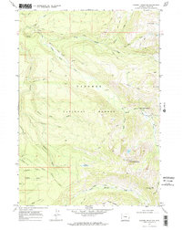
1968 Map of Rammel Mountain
USGS Topo · Published 1972About this map
Targhee National Forest defines the character of this 1968 landscape, where a intricate drainage network of creeks and high ridgelines dominates the terrain of Teton County. The map details a transition from the lower elevations near Jackpine Loop Rd to the prominent peaks of Mount Nord and Rammel Mountain. This era of the forest is captured through its primitive transportation network, including the Poacher Trail and various unnamed pack trails that navigate the steep ascent toward Dead Horse Pass.
Find a feature on this map
31 named features on this map. Tap any name to fly to it.
Don’t see what you’re looking for? This feature index may not catch every label — zoom into the map to look around manually.
Map Details
Editions of this 1968 Rammel Mountain Map
3 editions found
Other maps of this area

1886 · Shoshone
USGS Topo · 1:125,000

1888 · Shoshone
USGS Topo · 1:125,000

1895 · Shoshone
USGS Topo · 1:125,000

1899 · Grand Teton
USGS Topo · 1:125,000

1901 · Shoshone
USGS Topo · 1:125,000

1901 · Grand Teton
USGS Topo · 1:125,000

1908 · Shoshone
USGS Topo · 1:125,000

1911 · Shoshone
USGS Topo · 1:125,000

1955 · Ashton
USGS Topo · 1:250,000

1955 · Driggs
USGS Topo · 1:250,000