
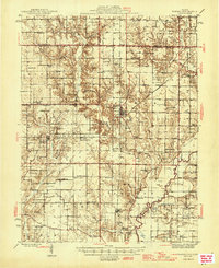
1946 Map of Ramsey
USGS Topo · Published 1946About this map
The Kaskaskia River snakes through the southeastern corner of this Fayette County landscape, which is defined by an extensive network of rural schools and family-centered cemeteries. The village of Ramsey serves as the primary hub, situated at the intersection of the Illinois Central and the New York Chicago and St Louis railroads. This rail crossroads was essential for moving agricultural goods from the surrounding prairie and timberlands.
Find a feature on this map
86 named features on this map. Tap any name to fly to it.
Don’t see what you’re looking for? This feature index may not catch every label — zoom into the map to look around manually.
Map Details
Editions of this 1946 Ramsey Map
2 editions found
Other maps of this area

1932 · Greenville
USGS Topo · 1:62,500

1939 · Greenville
USGS Topo · 1:62,500

1941 · St. Elmo
USGS Topo · 1:62,500

1942 · Shelbyville
USGS Topo · 1:62,500

1943 · Greenville
USGS Topo · 1:62,500

1944 · Ramsey
USGS Topo · 1:62,500

1945 · St. Elmo
USGS Topo · 1:62,500

1945 · Kinmundy
USGS Topo · 1:62,500

1945 · Vandalia
USGS Topo · 1:62,500

1946 · Shelbyville
USGS Topo · 1:62,500