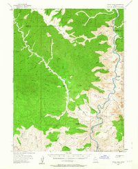
1954 Map of Range Creek
USGS Topo · Published 1963About this map
Range Creek carves a deep valley through the high plateau of the West Tavaputs, serving as a vital corridor of habitation in this isolated stretch of the Utah backcountry. The 1954 field check captures the remote operations at Pilling Ranch and Wilcox Ranch, situated where the canyon floor widens enough to support human activity. To the east, the landscape drops precipitously toward the Green River, which forms the boundary of the Uintah and Ouray Indian Reservation. The river flows through Desolation Canyon, flanked by dramatic features like Red Point and Florence Creek. The network of jeep trails and livestock paths, such as the one crossing Last Chance Benches, illustrates the era's reliance on rugged transportation for ranching and land management. The presence of Xmas Mtn and Big Horn Mtn highlights the significant vertical relief and the topographical complexity of the Emery and Carbon County lines.
Find a feature on this map
53 named features on this map. Tap any name to fly to it.
Don’t see what you’re looking for? This feature index may not catch every label — zoom into the map to look around manually.
Map Details
Editions of this 1954 Range Creek Map
3 editions found
Other maps of this area

1885 · East Tavaputs
USGS Topo · 1:250,000

1886 · Price River
USGS Topo · 1:250,000

1896 · Price River
USGS Topo · 1:250,000

1915 · Sunnyside
USGS Topo · 1:62,500

1948 · Woodside
USGS Topo · 1:62,500

1949 · Woodside
USGS Topo · 1:62,500

1950 · Woodside
USGS Topo · 1:62,500

1953 · Firewater Canyon
USGS Topo · 1:62,500

1954 · Flat Canyon
USGS Topo · 1:62,500

1954 · Range Creek
USGS Topo · 1:62,500