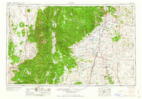
1958 Map of Raton
USGS Topo · Published 1958About this map
The Maxwell Land Grant and the Sangre de Cristo Mountains dominate this high-altitude landscape during the mid-1950s. The terrain transitions from the dramatic peaks of Wheeler Peak and Pueblo Peak in the Carson National Forest to the volcanic mesas of the east, including Raton Mesa and Johnson Mesa. Settlement patterns reflect the region's diverse history, from the ancient Taos Pueblo and the Spanish-heritage plazas of Arroyo Seco and Peñasco, to the mining and ranching hubs of Raton and Cimarron. The Atchison Topeka and Santa Fe RR follows the mountain's edge through Gale Station and Springer, while a Molybdenum mine near Questa points to the area's industrial resource extraction. Hydrological features like the Canadian River, Eagle Nest Lake, and Hebron Reservoir underscore the critical importance of water management in this arid northern New Mexico environment.
Find a feature on this map
151 named features on this map. Tap any name to fly to it.
Don’t see what you’re looking for? This feature index may not catch every label — zoom into the map to look around manually.
Map Details
Editions of this 1958 Raton Map
3 editions found

Other maps of this area

1889 · Las Vegas
USGS Topo · 1:125,000

1889 · Santa Fe
USGS Topo · 1:125,000

1891 · Las Vegas
USGS Topo · 1:125,000

1891 · Spanish Peaks
USGS Topo · 1:125,000

1891 · Mesa De Maya
USGS Topo · 1:125,000

1892 · Santa Clara
USGS Topo · 1:125,000

1892 · Watrous
USGS Topo · 1:125,000

1892 · Elmoro
USGS Topo · 1:125,000

1893 · Spanish Peaks
USGS Topo · 1:125,000

1893 · Las Vegas
USGS Topo · 1:125,000