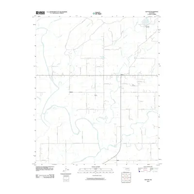
2010 Map of Rattan
USGS Topo · Published 2010About this map
The Kiamichi River winds through this section of Pushmataha County, anchoring a landscape defined by small rural settlements and a dense network of county roads. At the center of the survey lies Rattan, served by the Rattan Cemetery and connected to the surrounding countryside via routes like Pete Green Rd and Wild Horse Rd. Further south, the community of Belzoni sits near the riverbanks, with its namesake Belzoni Cemetery located just to the east.
Find a feature on this map
55 named features on this map. Tap any name to fly to it.
Don’t see what you’re looking for? This feature index may not catch every label — zoom into the map to look around manually.
Map Details
Editions of this 2010 Rattan Map
This is the sole edition of this map. No revisions or reprints were ever made.
Other maps of this area

1901 · Antlers
USGS Topo · 1:125,000

1901 · Alikchi
USGS Topo · 1:125,000

1912 · Antlers
USGS Topo · 1:125,000

1925 · Antlers
USGS Topo · 1:125,000

1950 · Mcalester
USGS Topo · 1:250,000

1961 · Antlers East
USGS Topo · 1:24,000

1962 · McAlester
USGS Topo · 1:250,000

1965 · McAlester
USGS Topo · 1:250,000
1969 · Hugo
USGS Topo · 1:24,000

1971 · Spencerville
USGS Topo · 1:24,000