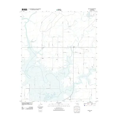
2012 Map of Rattan
USGS Topo · Published 2012About this map
Kiamichi River bottomlands dominate this landscape, where the winding river feeds into the northern reaches of Hugo Lake. The settlement of Rattan serves as the local hub, connected to outlying communities like Belzoni and Apple by a network of rural roads and trails such as Rattan Trl and Meeker Trl. Genealogists will find the Rattan Cem and Belzoni Cem clearly marked, providing essential locations for family history research in this part of Pushmataha County. The terrain is defined by its water, from the larger Lake Ozzie Cobb in the northeast to numerous seasonal drainages like Mill Cr, Rock Cr, and the descriptively named Sleepy Hollar. The area's geography reflects a reliance on the river system and small, dispersed residential clusters linked by long-established county routes.
Find a feature on this map
62 named features on this map. Tap any name to fly to it.
Don’t see what you’re looking for? This feature index may not catch every label — zoom into the map to look around manually.
Map Details
Editions of this 2012 Rattan Map
This is the sole edition of this map. No revisions or reprints were ever made.
Other maps of this area

1901 · Antlers
USGS Topo · 1:125,000

1901 · Alikchi
USGS Topo · 1:125,000

1912 · Antlers
USGS Topo · 1:125,000

1925 · Antlers
USGS Topo · 1:125,000

1950 · Mcalester
USGS Topo · 1:250,000

1961 · Antlers East
USGS Topo · 1:24,000

1962 · McAlester
USGS Topo · 1:250,000

1965 · McAlester
USGS Topo · 1:250,000
1969 · Hugo
USGS Topo · 1:24,000

1971 · Spencerville
USGS Topo · 1:24,000