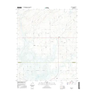
2016 Map of Rattan
USGS Topo · Published 2016About this map
The Kiamichi River defines the western reaches of this landscape, its winding course feeding into the expansive waters of Hugo Lake at the southern boundary. This area of southeastern Oklahoma is characterized by its numerous small creek drainages, including Mill Cr, Rock Creek, and Frazier Creek, which weave through the terrain between the Pushmataha and Choctaw county lines. The settlement pattern is anchored by Rattan, Belzoni, and Apple, connected by a network of rural routes and older paths like the Meeker Trl and Rattan Trl. Genealogists will find particular value in the documentation of the Rattan Cem and Belzoni Cem, which serve as permanent markers of the local families who settled these valleys. To the northeast, the presence of Lake Ozzie Cobb highlights the region's managed water resources, while the secluded label for Sleepy Hollow adds a specific sense of place to the rural geography.
Find a feature on this map
66 named features on this map. Tap any name to fly to it.
Don’t see what you’re looking for? This feature index may not catch every label — zoom into the map to look around manually.
Map Details
Editions of this 2016 Rattan Map
This is the sole edition of this map. No revisions or reprints were ever made.
Other maps of this area

1901 · Antlers
USGS Topo · 1:125,000

1901 · Alikchi
USGS Topo · 1:125,000

1912 · Antlers
USGS Topo · 1:125,000

1925 · Antlers
USGS Topo · 1:125,000

1950 · Mcalester
USGS Topo · 1:250,000

1961 · Antlers East
USGS Topo · 1:24,000

1962 · McAlester
USGS Topo · 1:250,000

1965 · McAlester
USGS Topo · 1:250,000
1969 · Hugo
USGS Topo · 1:24,000

1971 · Spencerville
USGS Topo · 1:24,000