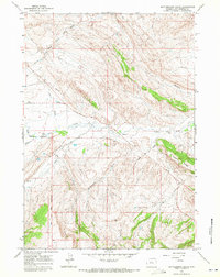
1965 Map of Rattlesnake Gulch
USGS Topo · Published 1972About this map
The Wind River Indian Reservation Boundary divides this landscape, marking a significant jurisdictional line through the arid drainage basins of Hot Springs County. The terrain is defined by a series of dry washes and intermittent streams, including Owl Creek, Pumpkin Creek, and Mud Creek, which cut through the high plains toward the Bighorn River system. The presence of Mines near the southern flank of Cedar Ridge suggests localized extractive industry, while a solitary Gaging Sta along the creek and a Pipeline crossing the northern draws reflect the management of water and energy resources in this open country.
Find a feature on this map
26 named features on this map. Tap any name to fly to it.
Don’t see what you’re looking for? This feature index may not catch every label — zoom into the map to look around manually.
Map Details
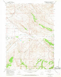
Editions of this 1965 Rattlesnake Gulch Map
2 editions found
Other maps of this area

1914 · Blue Mesa
USGS Topo · 1:62,500

1916 · Blue Mesa
USGS Topo · 1:62,500

1945 · Kirby
USGS Topo · 1:62,500

1946 · Kirby
USGS Topo · 1:62,500

1955 · Thermopolis
USGS Topo · 1:250,000

1958 · Thermopolis
USGS Topo · 1:250,000
1960 · Wedding Of The Waters
USGS Topo · 1:24,000

1960 · Thermopolis
USGS Topo · 1:24,000

1962 · Thermopolis
USGS Topo · 1:250,000
1965 · Potato Butte
USGS Topo · 1:24,000