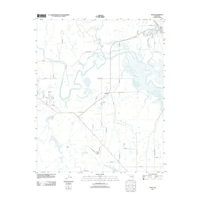
2013 Map of Ravia
USGS Topo · Published 2013About this map
The Washita River meanders through this portion of Oklahoma, defining a landscape of sharp river bends and low-lying wetlands. The small community of Ravia sits in the northeast corner of the sheet, centered on a grid of streets like College St and N Mill St, while the settlement of Russett serves as a secondary crossroads to the south. This area is notably rich in genealogical data, preserving the locations of several burial grounds including Ravia Cem, Mannsville Cem, Russett Cem, and Cedar Hill Cem. Infrastructure in the southern section is dominated by the Madill Municipal Airport and the path of Old Hwy 70. Numerous tributaries, such as Courtney Cr and Turkey Cr, drain into the main river channel, feeding local bodies of water like Randolph Lake and Carter Lake.
Find a feature on this map
65 named features on this map. Tap any name to fly to it.
Don’t see what you’re looking for? This feature index may not catch every label — zoom into the map to look around manually.
Map Details
Editions of this 2013 Ravia Map
This is the sole edition of this map. No revisions or reprints were ever made.
Other maps of this area

1901 · Tishomingo
USGS Topo · 1:125,000

1957 · Ardmore
USGS Topo · 1:250,000

1963 · Ardmore
USGS Topo · 1:250,000

1963 · Madill
USGS Topo · 1:24,000

1963 · Mannsville
USGS Topo · 1:24,000

1963 · Troy
USGS Topo · 1:24,000

1963 · Ravia
USGS Topo · 1:24,000

1963 · Mc Millan
USGS Topo · 1:24,000

1963 · Nebo
USGS Topo · 1:24,000
1967 · Tishomingo SW
USGS Topo · 1:24,000